The Lochstein stamping station is located directly on the Oberer Schalker Graben between the settlement of Festenburg and Clausthal-Zellerfeld.
The “Obere Schalker Graben”, built in 1716, collected the mountain water on its 8,980 m long path from the southern slope of the Schalke to Hahnenklee and led it to the Hahnenklee mines via several ponds.
There were perforated stones in all mining operations in Germany, but they are not usually located directly on the road or on hiking trails.
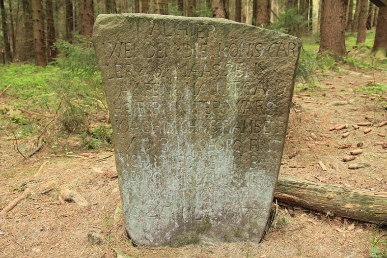
The perforated stone is a mine field boundary stone, also known as a marker stone, because it marks the “Markscheide” and was set by a “Markscheider” (surveyor in the mine). The inscription reads:
Alhier turn the king Carler 6 measures on the main course heir down it was
- Joachim Christian Behr V.O.B.M.
- Georg Fritrich Glessner U.B.M.
- Georg Niclaus Mersmann GE. W.
The best starting point is from the small settlement of Festenburg to the Lochstein. Festenburg can be reached via the country road from Schulenberg to Clausthal-Zellerfeld.
From the rustic “Grüne Tanne” inn, the hiking trail begins in the direction of Bockswiese, which first crosses the Unterer Schalker Graben and continues uphill to the Oberer Schalker Graben. There you follow the ditch path to the left to the Lochstein.
If you want to continue the hike to the Schalker Turm HWN 125, walk back a little and then follow the steeply ascending path towards Schalke.
